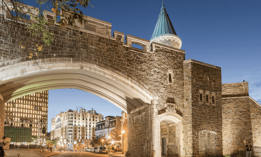
Most visitors to Old Québec walk past the fortifications dozens of times without really seeing them. You step through the Saint-Jean Gate on your way to dinner, you lean against a stone parapet to take a photo, you climb a set of stairs at Place d’Armes — and the whole time you’re moving through one of the most intact urban fortification systems surviving anywhere in the Americas. The only fully walled city north of Mexico, designated a UNESCO World Heritage Site in 1985, still functioning four centuries after it was begun.
The walls aren’t a reconstruction. Some sections date to the 1690s. Most of what you see dates from British construction between 1820 and 1860. None of it is decorative. These walls were built to kill attackers, and they’re still standing because, in the end, nobody seriously tried.
Here’s what you’re looking at, section by section, and how to actually walk it in a usable afternoon.
The Basic Geography
The fortifications of Québec City run about 4.6 kilometres around the Upper Town. They enclose the historic core — the Château Frontenac, the Place d’Armes, the residential streets of the haute-ville — in an irregular polygon that follows the natural topography of Cap Diamant. At the southwestern corner sits La Citadelle, the star-shaped fortress that is the keep of the whole system.
Four historic gates pierce the walls, providing entry from the surrounding city:
- Porte Saint-Louis — western entry, on Grande Allée, the main ceremonial gate.
- Porte Saint-Jean — also western, slightly north of Saint-Louis, the busy pedestrian gate.
- Porte Kent — north side, opening to the Saint-Jean-Baptiste neighbourhood.
- Porte Prescott — east side, overlooking the Lower Town and the Saint-Lawrence.
Additional smaller entrances (Porte des Carrières, Porte Hope — no longer existing) once existed but were demolished in the 19th century to ease traffic flow.
The Four-Century History (Compressed)
The first defensive walls around Québec were built by the French in the 1690s — relatively modest earthworks with wooden palisades. These were upgraded in stone during the French regime but remained fragmentary.
After the British conquest of 1759-60, the military engineers of the British army recognized that Québec’s natural geography (a city on a cliff, commanding the St. Lawrence) made it Canada’s most strategically important site. The existing French walls were expanded, reinforced, and eventually replaced by the comprehensive stone fortifications you see today. Most of this work happened between 1820 and 1850, under the leadership of Colonel Elias Walker Durnford — the same engineer who designed La Citadelle.
The walls were never seriously tested in combat. The American invasion of 1775 came before they were fully rebuilt. By the late 19th century, when they might have mattered, artillery had evolved to the point where traditional stone walls were obsolete. Québec’s fortifications became, instead, the most intact and best-preserved set of early 19th-century military walls in North America, effectively because they were kept without being used.
Walking the Wall: The Recommended Route
You can walk much of the fortification system on top of the ramparts themselves. It’s one of the best walks in the city, and it’s free. Here’s the clockwise route most visitors follow:
Stage 1: Porte Saint-Louis to Parc de l’Esplanade
Start at Porte Saint-Louis, the big stone gateway on Grande Allée. Climb the stairs on the south side (you’ll see signs) to reach the rampart walkway.
Walk south-east along the top of the wall. You’ll pass the Parc de l’Esplanade on your left — a grassy slope that used to be a military parade ground and is now one of the city’s favourite park spaces. This section gives you views over the Grande Allée and the historic Victorian-era hotels across the street.
Stage 2: Approaching La Citadelle
As you continue, the walls climb toward the star fort. You can’t walk directly into the Citadelle from here — it requires a separate ticket and guided tour — but you’ll pass the impressive exterior ramparts and get views of the defensive geometry up close.
Stage 3: Along the Cliff Edge
After rounding La Citadelle on its western side, the wall walkway heads north along the cliff edge above the Lower Town. This is the most scenic stretch. On your right, the St. Lawrence River stretches out below. On your left, you’re looking into the backs of historic residences. The air is cleaner up here, the views genuinely extraordinary.
You’ll pass several bastions — the angular stone projections in the wall designed to create crossfire positions. The most notable is the Bastion du Roi, near the Citadelle, which has cannons still in place (original pieces, not replicas).
Stage 4: Dufferin Terrace to Porte Prescott
The wall merges with the Dufferin Terrace, the famous boardwalk in front of the Château Frontenac. This is where most of the wall-walk terminates for visitors — you’re now in the heart of the tourist zone, with viewpoints, photographers, the funicular, and the whole Lower Town spread out below.
If you continue, Porte Prescott appears as a reconstructed gate on the eastern side. The original was demolished in 1871; the current version is a 1983 reconstruction using the original 19th-century plans. It’s a functional traffic gate today.
Stage 5: Porte Kent and Porte Saint-Jean
Completing the circuit requires crossing through the old town on foot — the wall system doesn’t offer a continuous walkway at this point because commerce and residences have filled in the original defensive geometry. Walk along Rue Saint-Jean, through Porte Saint-Jean (the busiest pedestrian gate), and eventually back to your starting point.
Total walking time for the whole loop: roughly 90 minutes at a leisurely pace, not counting stops. Plan for two hours with photos and pauses.
Specific Features to Notice
Loopholes (gun slits) — Narrow vertical openings in the wall, angled so defenders could fire outward while remaining almost completely covered. They appear in regular spacing and are perfectly sized to accommodate a musket or a small rifle.
Glacis — The gently sloping ground just outside the walls. Not an accident — engineered to give defenders a clear field of fire and to slow attackers’ momentum.
Ditches (or dry moats) — The low ground immediately beyond some sections of the wall. You can see the contours clearly around the Esplanade and near Porte Saint-Louis.
Sally ports — Small discreet doors in the wall where defenders could sortie out to attack besiegers. Most have been walled up but you can sometimes see their outlines.
Cannons — Some original 18th- and 19th-century artillery pieces remain in their original positions on the ramparts. Look for them along the cliff walk.
The Underground: Fortifications Below Ground Level
Part of the Québec fortification system is underground. Galeries, tunnels, and subterranean magazines run beneath sections of the walls. Most aren’t open to the public, but a few guided tours offered through Parks Canada occasionally include underground sections.
The Artillery Park National Historic Site at the north end of the fortifications includes a visitor centre with detailed models of the entire defensive system, and often provides access to underground spaces not normally accessible. If you have a strong interest in military history, make time for it.
Practical Walking Tips
Shoes: Good walking shoes with grip. The ramparts are mostly stone and uneven in places. In winter, icy patches are real.
Timing: Morning light (before 10 AM) is the best for photos along the eastern wall, afternoon (after 3 PM) for the Dufferin Terrace stretch. Avoid midday summer heat if possible.
Accessibility: The main walking paths are flat and wheelchair-accessible on the Dufferin Terrace section. Elsewhere, stairs and narrow passages make parts of the circuit challenging for visitors with mobility issues.
Weather: The walls are exposed on all sides. Bring a windbreaker even on warm days and expect full sun on the cliff sections. In winter, the walks are genuinely beautiful but require serious cold-weather gear.
Photography: Excellent throughout. The fortifications frame the city in ways that street-level shots can’t. Bring a wide-angle lens if you have one.
FAQ
Is there an entry fee?
No. Walking the ramparts and through the gates is free. Only La Citadelle and certain specific museums (Parks Canada visitor centres) charge admission.
Can I walk the walls at night?
The ramparts are generally unrestricted 24/7, but lighting is inconsistent in some sections. Stick to well-lit areas after dark. The Dufferin Terrace and main gate areas are well-lit.
Are guided tours available?
Yes. Parks Canada offers guided walking tours of the fortifications in summer, and several private operators offer variations year-round. Guided tours add historical context that self-guided walking doesn’t.
Is it safe?
Entirely. Old Québec is one of the safest urban environments in North America. The fortifications are well-maintained and heavily travelled by both locals and tourists.
How do the fortifications compare to European walled cities?
Québec’s fortifications are more intact than most European comparables — cities like York, Carcassonne, and Dubrovnik all have walls, but most have been heavily modified or partially demolished. Québec’s are unusually complete.
Final Word
Québec’s fortifications are one of those features that most visitors walk past repeatedly without realizing what they’re seeing. Spend two hours actually walking them — the full circuit, slowly, paying attention — and the whole city starts to read differently. You understand why the streets curve the way they do, why certain buildings sit where they do, why the entire urban fabric has the compact density that makes Old Québec feel so distinctive. The walls aren’t a decoration. They’re the organizing principle. Walking them is the shortest route to understanding the city.
The walls are a national historic site administered by Parks Canada, which publishes the interpretation programme, seasonal access and current visiting conditions for the Fortifications of Québec National Historic Site.